Imagine grabbing coffee, picking up groceries, and strolling through a park without getting in your car. If you want a daily routine that is simple and close to home, Cincinnati has several neighborhoods that make life on foot easy. You might be new to the city or rethinking your commute, but either way, choosing the right walkable area can save you time and stress. In this guide, you will learn what walkability looks like here, which neighborhoods shine, and how to pick the best fit for your lifestyle. Let’s dive in.
Walkability in Cincinnati
Walkability means you can handle everyday needs on foot within about a 5 to 20 minute walk. That includes groceries, coffee, parks, pharmacies, and useful services, plus sidewalks and safe crossings that make walking pleasant. Transit access also matters, since frequent buses or a streetcar connection can extend your car-light routine.
A quick way to compare areas is to check a neighborhood’s Walk Score. It grades locations by proximity to amenities and labels them from Walker’s Paradise to Somewhat Walkable. Use it as a starting point, then confirm the details you care about, like the nearest full-service grocery store, sidewalk quality, and transit frequency. You can explore general scoring methods on the Walk Score site for context about how the tool works.
- Reference: See how Walk Score explains its ratings on the Walk Score website.
Best walkable neighborhoods
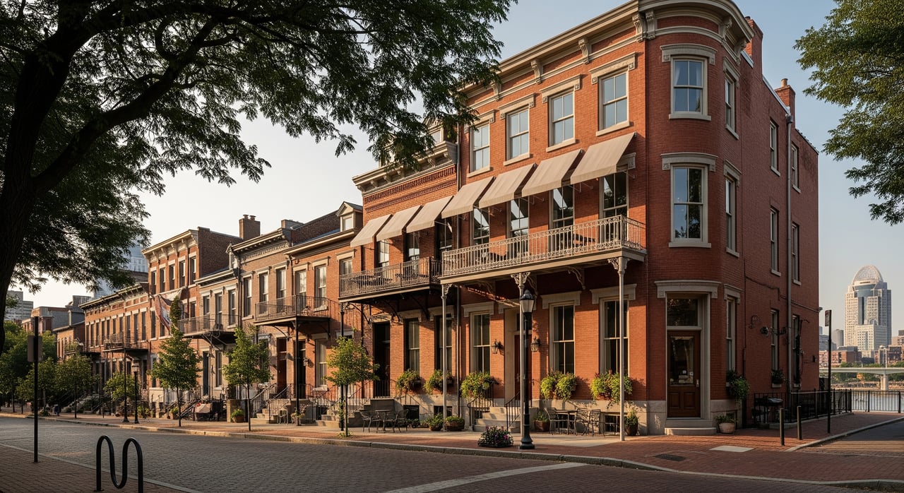
Over-the-Rhine (OTR)
OTR puts daily life at your doorstep. You can browse independent shops, grab dinner, and stock up on fresh produce at the historic public market without a car. The compact street grid and steady street life make short trips simple.
- Everyday errands: Find fresh food and staples at Findlay Market, plus cafés, restaurants, and small retailers.
- Transit snapshot: Multiple bus lines serve the area, and the Cincinnati Bell Connector streetcar links OTR to downtown and the riverfront.
- Housing snapshot: Restored brick rowhouses, loft condos, and apartments, with a mix of historic buildings and newer infill.
- Keep in mind: Evenings can be lively and parking is often limited, so weigh noise and storage needs against the convenience of walking.
Downtown / Central Business District
If you want to live close to work, dining, and riverfront parks, the CBD delivers. Many errands are within a few blocks, and the riverfront paths add accessible outdoor space.
- Everyday errands: Groceries, coffee shops, banks, restaurants, and theaters within easy reach.
- Transit snapshot: Hub for major bus routes and the streetcar, with strong regional connectivity.
- Housing snapshot: High-rise condos, mid-rise apartments, and renovated historic buildings.
- Keep in mind: Some blocks feel quieter on nights and weekends. Factor in condo fees and parking options when comparing buildings.
Mount Adams
Mount Adams offers a charming village feel right next to downtown. You get short walks to restaurants and scenic viewpoints, but the hills shape your day-to-day routine.
- Everyday errands: Small restaurants, bars, and quick bites, with parks and overlooks nearby.
- Transit snapshot: Close to downtown routes, though fewer buses run directly up the hill.
- Housing snapshot: Historic cottages, rowhomes, and small single-family houses.
- Keep in mind: Steep grades can make some walks strenuous, so consider mobility needs and daily routes.
Clifton / University Area
Around Ludlow Avenue, Clifton blends classic homes with a lively retail corridor. You will find an active pedestrian scene and many daily services linked to the nearby university and medical center.
- Everyday errands: Grocery options, pharmacies, coffee shops, bookstores, and a library.
- Transit snapshot: Multiple bus lines and university shuttles, with higher pedestrian volumes throughout the day.
- Housing snapshot: Historic single-family homes, duplexes, apartment buildings, and student rentals.
- Keep in mind: Activity levels vary by block. Expect some student turnover and occasional noise.
Northside
Northside centers on Hamilton Avenue, where independent shops and community spots create a strong walkable core. Neighborhood events and creative businesses add to the local vibe.
- Everyday errands: Local grocer options, cafés, restaurants, and vintage and specialty shops.
- Transit snapshot: Bus service connects to downtown and nearby neighborhoods.
- Housing snapshot: Smaller single-family homes, duplexes, historic cottages, plus some newer infill.
- Keep in mind: Infrastructure quality can vary by block. Commuting downtown often requires transit or a car.
Hyde Park (Hyde Park Square)
Hyde Park Square functions as a village center with a cluster of shops and services set among residential streets. Many residents can walk for coffee, dinner, and basic errands while enjoying a quieter feel.
- Everyday errands: Bakeries, restaurants, markets nearby, and personal services around the square.
- Transit snapshot: Bus routes serve the square with generally good inner-suburban access.
- Housing snapshot: Predominantly early 20th-century single-family homes, with some condos and apartments near the square.
- Keep in mind: Streets farther from the square are more car-oriented. This area suits a walk-to-center lifestyle, not necessarily car-free living.
Oakley (Oakley Square / Madison Road)
Oakley gives you an energetic node of shops and restaurants along Madison Road and around the square. You can handle many errands on foot, with more suburban blocks just beyond the core.
- Everyday errands: Local dining, retail, and services clustered in the square, with grocery options within a short walk or drive depending on exact location.
- Transit snapshot: Bus lines run along major corridors, with some bike lanes in segments.
- Housing snapshot: Single-family homes, duplexes, and some newer townhomes and apartments.
- Keep in mind: Many residential streets were built for cars. It is a good balance of walkable amenities and traditional housing stock.
Pleasant Ridge
Pleasant Ridge offers a friendly business corridor along Ridge Road with restaurants and neighborhood services. If you want a small-center walkability experience, this is a solid option.
- Everyday errands: Local eateries, a bakery, and small businesses with a community feel.
- Transit snapshot: Bus service is available but less frequent than in central neighborhoods.
- Housing snapshot: Early-to-mid-20th-century single-family homes and some duplexes.
- Keep in mind: You may drive for larger grocery trips or certain healthcare services.
Other walkable pockets to explore
Several areas offer smaller walkable nodes within broader residential settings. Walnut Hills has emerging commercial corridors and historic homes. Evanston and Mt. Lookout feature village centers and parks. Columbia-Tusculum has river access and a spread-out, scenic feel. These can be great fits if you want a quieter block with a nearby cluster of amenities.
What to weigh before you buy
Choosing a walkable neighborhood involves trade-offs. Use this checklist to compare areas block by block.
- Daily errands: Map the nearest full-service grocery and pharmacy, plus coffee, parks, and basic services.
- Transit frequency: A nearby bus or the streetcar helps most if service runs often enough for your schedule.
- Parking and storage: Confirm garage, permit, or on-site options if you still need a car, bikes, or gear.
- Noise and nightlife: Visit during evenings and weekends to gauge activity levels and building sound insulation.
- Topography and access: Hills in Mount Adams and parts of Clifton can affect your routine and mobility.
- Schools and boundaries: If schools matter for your household, confirm district lines and nearby options.
- Sidewalks and crossings: Look for complete sidewalks, lighting, and safe intersections on your typical routes.
Car-light and car-free living
Cincinnati’s core neighborhoods make car-light living realistic. The Cincinnati Bell Connector streetcar links downtown and Over-the-Rhine for quick trips without parking hassles. Several frequent bus corridors operated by SORTA bring reliable connections between central neighborhoods, the University of Cincinnati area, and job centers. Red Bike docking stations are concentrated downtown and around nearby districts, which helps extend your walking radius with short bike hops.
If you plan to live fully car-free, focus on OTR, Downtown, and select blocks in Clifton and Northside where daily needs and transit lines cluster. In Hyde Park and Oakley, you can walk to the square for many errands, though a car or bus may still be practical for larger trips.
How to test a neighborhood on foot
Before you commit, try a real-world walk test.
- Do a weekday and a weekend visit, plus an evening walk.
- Time your walk to a grocery, pharmacy, and park.
- Ride the streetcar or take a bus to your likely commute destination.
- Note sidewalk quality, lighting, crosswalks, and any steep grades.
- Ask yourself if the building type suits your routine. Condos and apartments can make car-optional living more convenient with features like bike storage and package rooms.
For a quick orientation on amenity proximity, review how ratings are calculated on the Walk Score website. If OTR is on your shortlist, preview vendors and hours at Findlay Market to see how weekly grocery runs could work for you.
Ready to compare homes near your favorite square or corridor and line up tours that highlight daily life on foot. Reach out to Close to Home Consultants for local guidance, on-the-ground insights, and a plan tailored to your walking routine.
FAQs
Which Cincinnati neighborhoods support car-free living for daily needs
- OTR and Downtown are the most practical for many households, with parts of Clifton and Northside also workable; Hyde Park and Oakley offer walk-to-center convenience but may still call for transit or a car for bigger trips.
How does walkability compare between OTR and Hyde Park Square
- OTR provides dense, mixed-use blocks with the streetcar and many services close together; Hyde Park Square offers a quieter village center surrounded by more car-oriented residential streets.
Is Mount Adams truly walkable for daily errands given the hills
- Yes for local dining and social life, but steep grades can make routine walks strenuous; check your specific routes and mobility needs before deciding.
Where can you walk for groceries in Over-the-Rhine
- Findlay Market serves as a central grocery hub with produce, meat and fish vendors, and specialty items; explore vendors and hours on the Findlay Market site.
What should I evaluate before buying in a walkable Cincinnati area
- Confirm grocery and pharmacy distance, transit frequency, parking and storage, sidewalk and lighting quality, evening activity levels, and any hills along your typical routes.